Image:Congo regions named.png

From Wikipedia

Congo_regions_named.png (13KB, MIME type: image/png)

This file is a shared upload and may be used by other projects.

Description

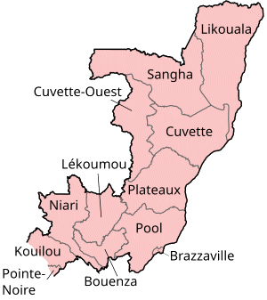
Map of the regions of the Republic of the Congo, named in French (local language), mostly compatible with English. The individual maps are:

Source

Self-made, traced from public domain UN or CIA maps.

Date

December 2004

Author

User:Golbez

Permission

Provide attribution, please. See below.

I, the author of this work, hereby publish it under the following licenses:
Some rights reserved
Creative Commons Attribution iconCreative Commons Share Alike icon
This file is licensed under the Creative Commons Attribution ShareAlike license versions 2.5, 2.0, and 1.0
GNU head Permission is granted to copy, distribute and/or modify this document under the terms of the GNU Free Documentation License, Version 1.2 or any later version published by the Free Software Foundation; with no Invariant Sections, no Front-Cover Texts, and no Back-Cover Texts. A copy of the license is included in the section entitled "GNU Free Documentation License".

العربية | Česky | Deutsch | English | Español | Français | Italiano | 日本語 | 한국어 | Nederlands | Polski | Português | Slovenčina | Svenska | עברית +/-

You may select the license of your choice.

The following pages link to this file: