Hurricane Flora
From Wikipedia, the free encyclopedia

| Category 4 hurricane (SSHS) | ||
|---|---|---|
 Radar image of Hurricane Flora |
||
| Formed | September 26, 1963 | |
| Dissipated | October 12, 1963 | |
| Highest winds |
|
|
| Lowest pressure | 940 mbar (hPa) | |
| Damage | $528 million (1963 USD) $3.5 billion (2006 USD) |
|
| Fatalities | 7,186 - 8,000[1] | |
| Areas affected |
Lesser Antilles, Haiti, Cuba | |
| Part of the 1963 Atlantic hurricane season |
||
Hurricane Flora is among the deadliest Atlantic hurricanes in recorded history, with a death total of over 7,000. The seventh tropical storm and sixth hurricane of the 1963 Atlantic hurricane season, Flora developed from a disturbance in the Intertropical Convergence Zone on September 26 while located about 755 miles (1220 km) southwest of the Cape Verde islands. After remaining a weak depression for several days, it rapidly organized on September 29 to attain tropical storm status. Flora continued to quickly strengthen to reach Category 3 hurricane status before moving through the Windward Islands and passing over Tobago, and it reached peak winds of 140 mph (225 km/h) in the Caribbean Sea. It struck southwestern Haiti near peak intensity, turned to the west, and drifted over Cuba for four days before turning to the northeast. Flora passed through the Bahamas and accelerated northeastward, becoming an extratropical cyclone on October 12.
Contents |
[edit] Storm history

A disturbance in the Intertropical Convergence Zone organized into a tropical depression on September 26 while located about 755 miles (1220 km) southwest of the island of Fogo in the Cape Verde Islands. Upon forming, the depression had a poorly-organized circulation with banding features to its north and east. The depression moved west-northwestward, and the system failed to organize significantly by a day after developing. On September 27, the banding features dissipated, though the area of convection around the center increased. Satellite imagery was unavailable until September 30, during which there were not sufficient ship reports to indicate the presence of a low-level circulation. The depression continued west-northwestward, and it is estimated it intensified into Tropical Storm Flora on September 29 while located about 560 miles (900 km) east-southeast of Trinidad, or about 350 miles (570 km) north of Cayenne, French Guiana. Operationally, advisories were not initiated until a day later.[1]
Flora quickly intensified after it became a tropical storm, and early on September 30 it attained hurricane status. Later that day, Reconnaissance Aircraft confirmed the existence of the hurricane, with the flight reporting a well-defined, circular 8 mile wide eye. One observer noted Flora to be the best organized tropical cyclone over the previous two years. After attaining major hurricane status, Flora passed directly over the island of Tobago late on the 30th with winds of 120 mph. The hurricane continued west-northwestward as it entered the Caribbean Sea, and early on October 2 it reached winds of 140 mph. 30 hours later, Flora intensified slightly further and attained peak winds of 145 mph while located about 105 miles (170 km) south of the border of Haiti and the Dominican Republic.[1]

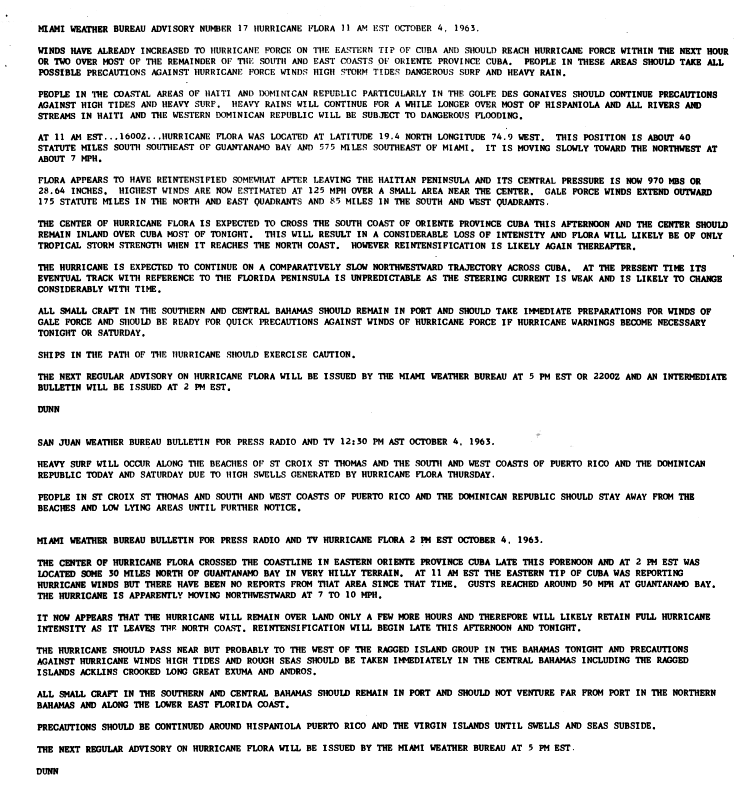
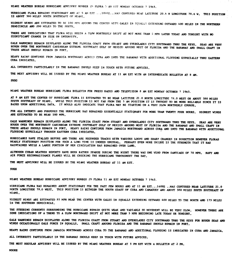
After turning to the northwest, Hurricane Flora maintained its peak strength, and made landfall in the Sud Department of Haiti early on October 4 as a 145 mph Category 4 hurricane on the Saffir-Simpson Scale with gusts from 180 to 200 mph.[2] The calm of the eye lasted for up to 70 minutes in one location.[3] After quickly weakenening to a 120 mph hurricane, Flora turned more to the west in the Windward Passage, and restrengthened slightly to strike southeastern Cuba about 30 miles east of Guantanamo Bay with winds of 125 mph. A high pressure system to its north turned the motion of the hurricane to a westward drift, causing it to weaken quickly over land. Flora neared the north coast of Cuba on October 4 before turning to the south. It executed a cyclonic loop and entered the coastal waters off of the Granma Province. An anticyclone to the west of Flora turned the hurricane to the north, bringing it ashore near Santa Cruz del Sur on October 7 with winds of around 90 mph. Flora initially turned southeastward over central Cuba, and late on October 8 a short-wave trough turned the hurricane northeastward, bringing it into the coastal waters of the Holguín Province.[1] Flora remained a hurricane while drifting over land due to abundant moisture and a favorable upper level environment.[2]
After passing over the southeastern Bahamas early on October 9, Flora began to restrengthen, and on October 10 it reached major hurricane status while located 290 miles (465 km) south of Bermuda. The hurricane gradually weakened as it continued northeastward, and weakened to a Category 1 hurricane on October 11. Flora gradually lost its convection over the north Atlantic Ocean, and transitioned into an extratropical cyclone on October 12 while located 270 miles (435 km) east-southeast of Cape Race, Newfoundland. The extratropical remnant dissipated the next day.[1]
[edit] Preparations
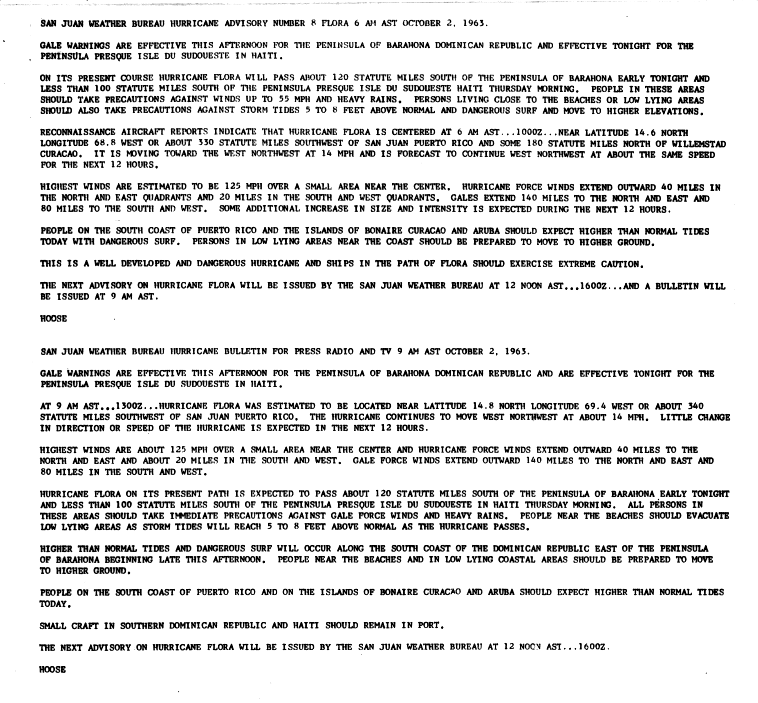
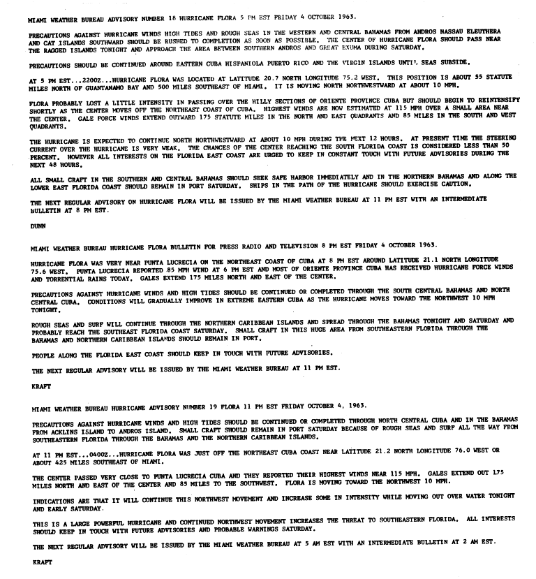
The Weather Bureau in San Juan, Puerto Rico issued a hurricane warning for Trinidad, Tobago, and the Grenadines south of Saint Vincent in the cyclone's first advisory on Hurricane Flora. Gale warnings were later issued for islands off of northern Venezuela[2] and from Saint Vincent northward to Martinique. Advisories on Flora emphasized the danger of the hurricane and advised preparations to be rushed to completion. The advisories also recommended small craft throughout the Windward Islands to remain at harbor and for shipping in the path of the hurricane to advise extreme caution.[4] People in low-lying areas and near beaches were advised to evacuate to higher grounds, as well.[5] Lead time was short, especially in Tobago which received news of the approaching hurricane just two hours before it struck.[6]
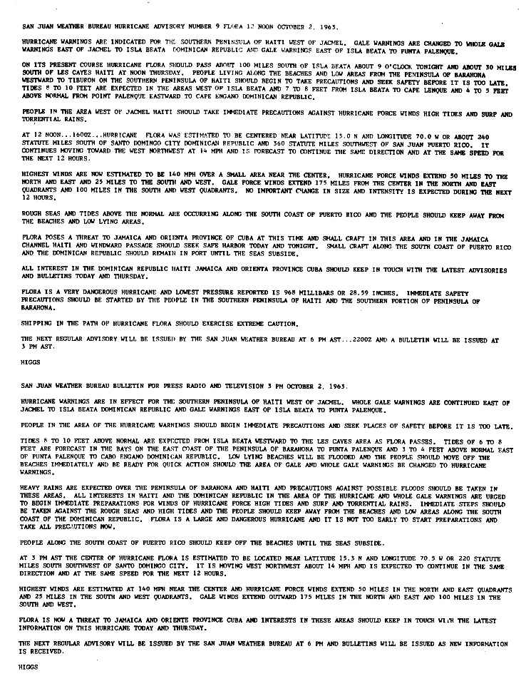
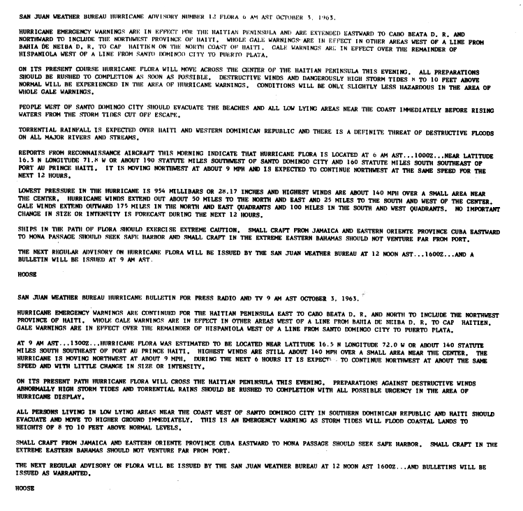
On October 2, two days before it made landfall on southwestern Hispaniola, the San Juan Weather Bureau issued a gale warning from Barahona in the Dominican Republic to the Sud-Est Department of Haiti. Advisories recommended small craft in the southern portions of the countries to remain at port.[7] Later that day, the gale warning was upgraded to a hurricane warning in southwestern Haiti.[8] On the day of when Flora made landfall, advisories recommended all citizens on beaches and in low-lying areas west of Santo Domingo to evacuate.[9] Carmelo Di Franco, the provisional Director of Civic Defense for the Dominican Republic, organized safety procedures and the dissemination of tropical cyclone bulletins from the San Juan Weather Bureau. Di Franco also organized for the transmission of hurricane emergency information to citizens, believed to reduce the loss of life.[3] On the afternoon before the hurricane struck, the head of the Haitian Red Cross prohibited radio broadcasts of tropical cyclone advisories for fear of panic among citizens. As a result, many thought the hurricane would miss the country.[10]
Officials at the Cuban National Observatory issued radio bulletins on the hurricane, which included the position of Flora, its intensity, direction of motion, and necessary warnings. By the time the hurricane left the island, more than 40,000 had been evacuated to safer areas.[11]
The Weather Bureau predicted Flora to turn to the northwest after entering the Windward Passage and affect the Bahamas.[12] Forecasters advised those in the Bahamas to quickly complete preparations, though the eye of the hurricane did not pass over the archipelago until four days later. When Flora turned to the northeast out to sea, forecasters again advised Bahamaian citizens to prepare for the hurricane. One advisory considered there to be less than a 50% chance of the hurricane reaching southeastern Florida, though weather bulletins advised Florida citizens to monitor the hurricane. At its closest approach to Florida, the hurricane remained 330 miles (530 km) away, though gale warnings were issued from Stuart to Key West due to the hurricane's large size.[13][14]
[edit] Impact
| Region | Deaths | Damage (1963 USD) |
Damage (2006 USD) |
|||
|---|---|---|---|---|---|---|
| Tobago | 18 | $30 million | $198 million | |||
| Trinidad | 2 | $100,000 | $660,000 | |||
| Grenada | 6 | $25,000 | $165,000 | |||
| Dominican Republic | 400+ | $60 million | $395 million | |||
| Haiti | 5,000 | $125 million | $825 million | |||
| Cuba | 1,750 | $300 million | $2 billion | |||
| Jamaica | 11 | $11.9 million | $78.4 million | |||
| Bahamas | 1 | $1.5 million | $50 million | |||
| Florida | 1 | 0 | 0 | |||
| Total | 7,189 | $528.6 million | $3.5 billion | |||
| Source: [2] | ||||||
Throughout its path, Hurricane Flora resulted in over 7,000 deaths and over $525 million in damage (1963 USD, $3.5 billion 2006 USD). It is estimated that if a hurricane like Flora struck in 1998 it would cause over 12,000 casualties.[3]
[edit] East Caribbean
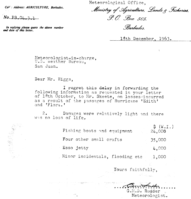
Hurricane Flora passed Barbados a few days after Hurricane Edith moved through the area. The two hurricanes resulted in about $65,000 in damage (1963 USD), primarily to fishing interests.[15]
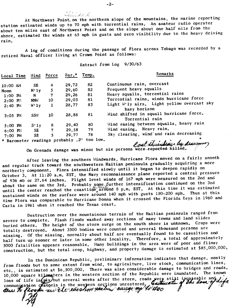
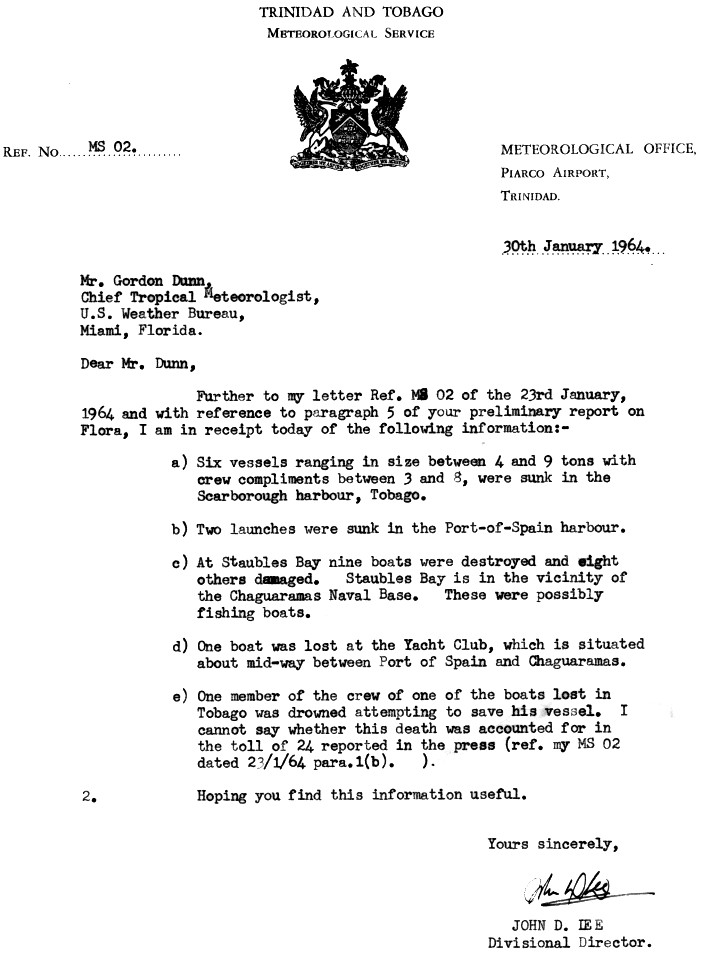
About four hours before the eye of Hurricane Flora moved over Tobago, the large hurricane began producing heavy rainfall throughout the island. Two hours later, strong winds began affecting the island, and while moving across the island Flora produced winds of up to 100 mph.[1][16] While moving past the island, the hurricane produced rough surf and 5 to 7 feet above normal tides.[4] The passage of the hurricane sunk six ships between 4 to 9 tons in Scarborough harbour. One crew member drowned while attempting to save his vessle.[17] Heavy rainfall caused a large mudslide from Mount Dillon onto a road leading to Castara. This was considered the most well-known mudslide on the island.[18] The strong winds severe damage to coconut, banana, and cocoa plantations,[19] with 50% of the coconut trees being destroyed and another 11% being severely damaged. 75% of forest trees fell, and most of the remaining were greatly damaged. The passage of Hurricane Flora destroyed 2,750 of Tobago's 7,500 houses, and damaged 3,500 others. The hurricane killed 18 on the island and resulted in $30 million in crop and property damage (1963 USD).[20]
Winds on Trinidad reached 55 mph with much higher gusts of over 70 mph. Heavy rainfall and strong winds in the northern mountainous region lowered the visibility to zero. Due to the mountain range on its northern coast, damage on the island was minimal, totaling to $100,000 (1963 USD).[1] Two people on the island died due to drowning.[20] When Flora passed the island and the winds turned to the southwest, many small boats in the westward facing harbor were sunk.[1] Near Chaguaramas, nine boats were destroyed and eight were damaged.[17] Additionally, several large vessles sustained damage and resulted in them being intentionally sunk. Damage in Grenada was minor, around $25,000 (1963 USD), though six people died due to drowning.[1] Rough seas and higher than normal tides were reported along the south coast of Puerto Rico,[8] though no damage or deaths were reported there.[1]
[edit] Dominican Republic
Flora produced heavy rainfall and moderately strong winds in the Dominican Republic. Flooding from the hurricane, considered to be the most extensive on record, greatly damaged bridges and roads, with many roads left unpassable by several months after the hurricane struck. Over 3,800 sq. miles (10,000 sq. km) in the western portion of the country were flooded. The hurricane caused about $60 million in damage (1963 USD) and over 400 deaths.[1]
[edit] Haiti
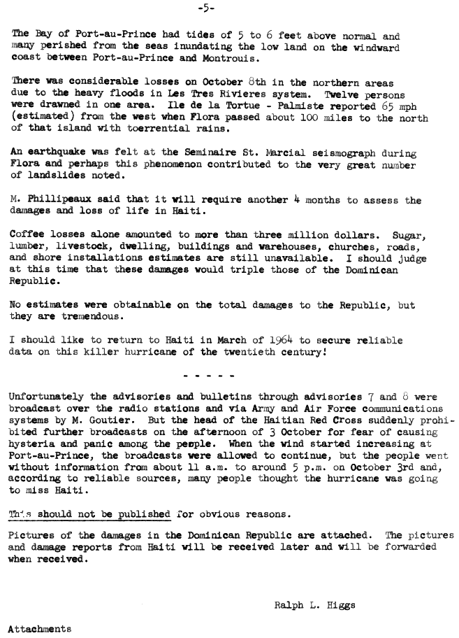
While moving across southwestern Haiti, Hurricane Flora produced winds of up to 120 mph near Derez,[1] while the capital city of Port-au-Prince reported peak winds of 65 mph (102 km/h).[21] Intense rainbands dropped torrential precipitation estimated at over 75 inches in Miragoane, with one location recording over 57 inches in three days. The storm surge on the southern coast is unknown, but estimated to exceed 12 feet.[1] Flash floods from the hurricane washed out large sections of several towns, while mudslides buried some entire towns. In most areas, crops were entirely destroyed.[1] The coffee crop was harvested prior to the arrival of the hurricane, though heavy rainfall and severe flooding ruined the crop for later years. Additionally, strong winds downed shading trees for the coffee crop in the southern peninsula. One official estimated it would require three years for the coffee crop to be replanted and regrown.[21] About 3,500 people were confirmed dead, with several thousands missing at one report five months after the hurricane. It is estimated the passage of Hurricane Flora killed around 5,000 people and caused between $125 million to $180 million in damage in Haiti (1963 USD).[1]
[edit] Cuba
| Deadliest Atlantic hurricanes | |||
|---|---|---|---|
| Rank | Hurricane | Season | Fatalities |
| 1 | "Great Hurricane" | 1780 | 22,000 |
| 2 | Mitch | 1998 | 11,000 – 18,000 |
| 3 | "Galveston" | 1900 | 8,000 – 12,000 |
| 4 | Fifi | 1974 | 8,000 – 10,000 |
| 5 | "Dominican Republic" | 1930 | 2,000 – 8,000 |
| 6 | Flora | 1963 | 7,186 – 8,000 |
| 7 | "Pointe-a-Pitre" | 1776 | 6,000+ |
| 8 | "Newfoundland | 1775 | 4,000 – 4,163 |
| 9 | "Okeechobee" | 1928 | 4,075+ |
| 10 | "San Ciriaco" | 1899 | 3,433+ |
| Main article: List of deadliest Atlantic hurricanes | |||
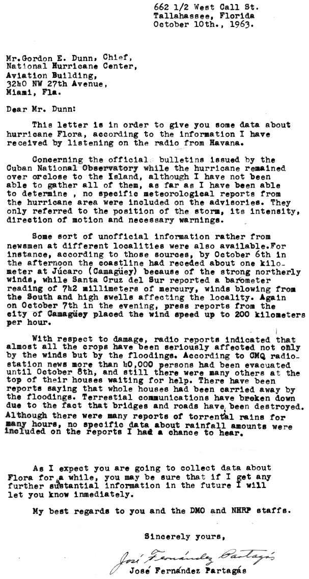
Strong northerly winds from Flora eroded the northern beaches in the Cuban province of Camagüey by up to 3,300 feet (1 km). Santa Cruz del Sur reported strong southerly winds and rough seas. Winds in Cuba reached 125 mph (200 km/h). Nearly all crops in southeastern Cuba were affected by strong winds and flooding. Many were left stranded at the tops of their houses. Several entire houses were swept away by the flooding. Many roads and bridges were destroyed, resulting in major disruptions to communications.[11]
Isolated locations in Cuba received over 80 inches of rain.[4]
[edit] Aftermath
- See also: List of retired Atlantic hurricanes
In Tobago, the great agricultural damage from Flora caused the crop plantations to be abandoned. As a result, the economy of the island changed towards tourism.[19] The destruction of the Tobagan rainforests resulted in continual decline of agriculture on the island due to animals previously in the forest eating the crops for food.[22] The passage of the hurricane reduced the height of the rainforest canopy from 800 feet to 400 feet. 25 years passed before the canopy reached its previous height.[23]
In the Dominican Republic, damage reports were largely unknown by a month after the hurricane passed the island, primarily in the western provinces. There, roads were still impassable, large areas remained without electricity, and helicopters could not land in remote areas due to mud, silt, and up to 3 feet of water in all landing fields. One official estimated several months would pass before survey teams could obtain information on loss of life and overall damages.[24]
[edit] See also
- List of notable Atlantic hurricanes
- List of retired Atlantic hurricanes
- List of South America tropical cyclones
[edit] External links
[edit] References
- ^ a b c d e f g h i j k l m n o Gordon E. Dunn (1964). The Hurricane Season of 1963. U.S. Weather Bureau Office. Retrieved on 2006-11-27.
- ^ a b c National Hurricane Center (1963). Hurricane Flora Preliminary Report Page Three. Retrieved on 2006-11-27.
- ^ a b Ralph L. Higgins (1963). Hurricane Flora Subsequent Report to the Dominican Republic and Haiti Page 2. San Juan Weather Bureau Office. Retrieved on 2006-12-04.
- ^ a b Higgs (1963). Hurricane Flora Advisories (Page 4). San Juan Weather Bureau. Retrieved on 2006-11-28.
- ^ Hoose & Davis (1963). Hurricane Flora Advisories (Page 5). San Juan Weather Bureau. Retrieved on 2006-11-28.
- ^ U.S. Weather Bureau (1963). Report of Preliminary Evaluation of Warning Services, Hurricane Flora. Retrieved on 2006-11-28.
- ^ Hoose (1963). Hurricane Flora Advisories (Page 9). San Juan Weather Bureau. Retrieved on 2006-11-28.
- ^ a b Higgs (1963). Hurricane Flora Advisories (Page 10). San Juan Weather Bureau. Retrieved on 2006-11-28.
- ^ Hoose (1963). Hurricane Flora Advisories (Page 14). San Juan Weather Bureau. Retrieved on 2006-11-28.
- ^ Ralph L. Higgins (1963). Hurricane Flora Subsequent Report to the Dominican Republic and Haiti Page 5. San Juan Weather Bureau Office. Retrieved on 2006-12-04.
- ^ a b José Fernández Partagás (1963). Information from Cuba. National Hurricane Center. Retrieved on 2006-11-29.
- ^ Dunn (1963). Hurricane Flora Advisories (Page 19). Miami Weather Bureau. Retrieved on 2006-11-28.
- ^ Sugg & Moore (1963). Hurricane Flora Advisories (Page 26). Miami Weather Bureau. Retrieved on 2006-11-28.
- ^ Dunn & Kraft (1963). Hurricane Flora Advisories (Page 20). Miami Weather Bureau. Retrieved on 2006-11-28.
- ^ G.M.D. Rudder (1963). Letter from Barbados describing damage from Hurricanes Edith and Flora. Barbados Ministry of Agriculture, Lands, and Fisheries. Retrieved on 2006-11-29.
- ^ Miami, Florida Weather Bureau Office (1963). Hurricae Flora, September 26 - October 13. Retrieved on 2006-11-28.
- ^ a b John D. Lee (1963). Trinidad and Tobago Effects. Trinidad and Tobago Meteorological Service. Retrieved on 2006-11-29.
- ^ Stanley Wharton (2004). Living with Geohazards. Tobago News. Retrieved on 2006-11-28.
- ^ a b Tobago Dive Experience (2006). General information for Tobago. Retrieved on 2006-11-28.
- ^ a b C. B. Daniel, R. Maharaj, & G. De Souza (2002). Tropical Cyclones Affecting Trinidad and Tobago, 1725 to 2000. Trinidad and Tobago Meteorological Service. Retrieved on 2006-11-28.
- ^ a b Ralph L. Higgins (1963). Hurricane Flora Subsequent Report to the Dominican Republic and Haiti Page 3. San Juan Weather Bureau Office. Retrieved on 2006-12-04.
- ^ Tobago News (2005). Cocrico killing agriculture. Retrieved on 2006-11-28.
- ^ Patricia Turpin (2004). 'Ivan the Terrible' and the trees. Tobago News. Retrieved on 2006-11-28.
- ^ Ralph L. Higgins (1963). Hurricane Flora Subsequent Report to the Dominican Republic and Haiti Page 1. San Juan Weather Bureau Office. Retrieved on 2006-12-04.
|
|
|||||||||||||||||||||||

